The Bhutan Gangkhar Puensuum Trek is now open for registration.
FOLKWAYS INSTITUTE
14600 SE Aldridge Road
Happy Valley, OR 97086-6518 USA
Folkways_Institute@msn.com
__________________________________________
Happy Valley, OR 97086-6518 USA
Folkways_Institute@msn.com
__________________________________________
MISSION STATEMENT
FOLKWAYS INSTITUTE, a small, 501-c-3 non-profit, U.S. based, international organization was founded in 1978 and provides International Community-Based Service Projects, Research and Cultural Journeys in various overseas locations. Our Journeys emphasize life-long learning in a creative, stimulating environment while promoting cross-cultural understanding. Our administrative office is in Portland, Oregon and our campus is the diverse cultural and geographic settings of our global community that provides an environment for experiential and academic learning. We believe that an individual's growth in understanding international relationships requires a prepared, personal encounter with regional nationalities and the environment that molds their culture.
Thursday
Subscribe to:
Post Comments (Atom)
Subscribe to receive Updates and Posts via email or write to us: Folkways_Institute@msn.com
SCHEDULE OF TREKS, OUTINGS AND JOURNEYS
2011
2012
PATAGONIA: PARKS OF PATAGONIA TREK --- February --- Register by 01 June 2011 --- 10 Spaces Available
NEPAL: DOLPO-CRYSTAL MOUNTAIN TREK --- October --- Register by 05 January 2012 --- 10 Spaces Available
JOURNEYS, OUTINGS AND TREKS
A Detailed Itinerary and Trek Application are available by request.
PATAGONIA
PATAGONIA: PARKS OF PATAGONIA NATURAL HISTORY TREK
TREK DATES: 01 – 22 February 2012 (ElderFolk 55+ years)
REGISTRATION DEADLINE: 10 March 2009
TREK FEE: $6610.00 for 10 - 12 Members or $6975.00 for 8 - 9 Members
TREK FEE (EXCLUDING AIRFARE): $5350.00 for 10 - 12 Members or $5715.00 for 8 - 9 Members
ACTIVITY LEVEL: Bus, Hiking, Camping, Hotels
OVERVIEW:
We return to Argentina for a repeat of our previous Patagonia journey, with a few changes in our 2010 schedule.
Our journey will experience Patagonia in a combined day hiking and trekking program including: a cruise to Moreno Glacier, a trek across the front of Fitzroy and day hikes in Torres del Paine National Park and Bariloche with a little geology and birding thrown in. We will have a small group whose focus is cultural and natural history. Overnights will be both camping and in classic
An optional 5 days in
SCHEDULE:
01 FEBRUARY [Monday] DEPART HOMETOWN
02 FEBRUARY [Tuesday] ARRIVE IN
03 FEBRUARY [Wednesday] BUENOS AIRES/EL CALAFATE: Morning flight from
04 FEBRUARY [Thursday] MORENO GLACIER: Full day excursion to the Moreno Glacier, one of the most astonishing sights in
05 FEBRUARY [Friday] FITZROY CIRCUIT: Morning departure for Fitz Roy. We will drive east along the valley for an hour, then we turn north, cross the
06 FEBRUARY [Saturday] FITZROY CIRCUIT: We hike for a couple of hours to the base campsite at Piedra Fraile (4.5 miles/300’gain). Afternoon hike to Pollone Glacier and Lago Eléctrico near the Marconi pass. Back to camp at Piedra Fraile for two nights here. During hikes we carry our trail lunches while a superb dinner always awaits us in the evening. (BLD)
07 FEBRUARY [Sunday] FITZROY CIRCUIT: Cuadrado Pass Hike (3.5 miles/2499’ gain). (BLD)
08 FEBRUARY [Monday] FITZROY CIRCUIT: We leave early following the course of Blanco River and climb to Piedras Blancas Glacier from where we have astonishing views of the Fitz Roy massif. We then proceed hiking uphill to the Laguna de Los Tres with yet another spectacular, but different, view of Mount Fitz Roy(10.5 miles/2151’gain). Camp at Rio Blanco for one night. (BLD)
09 FEBRUARY [Tuesday] FITZROY CIRCUIT: Early breakfast in the beech forest before leaving this camp towards Cerro Torre. Small glacier lagoons like the Madre e Hija will show up in a contrasting landscape of Andean proportions. We arrive at Laguna Torre where we set camp. From this idillic setting we contemplate one of the most imposing mountains of
10 FEBRUARY [Wednesday] FITZROY CIRCUIT: Possibly the most spectacular trekking day you may ever have. We hike first to the Loma de Pliegue Tumbado until we get to the "Las Agachonas" (The Seedsnipes) mountain pass. Gorgeous views of Fitz Roy river and the Rio Tunel valley from here. Then we slowly walk down along this valley on to the Laguna Toro campsite where we camp (8.4 miles/2600’gain/loss). (BLD)
11 FEBRUARY [Thursday] FITZROY CIRCUIT: From Laguna Toro we return following the course of Rio Tunel up to its outfall in Viedma Lake and then we head north along the Pliegue Tumbado until we reach El Chalten town for a good rest and dinner at the local hostal (11.39 miles/1909 gain/2586 loss) (BLD)
12 FEBRUARY [Friday] FITZROY/CERRO CASTILLO: Bus ride south towards El Calafate and then proceed westwards along the Patagonian steppe to
13 FEBRUARY [Saturday] TORRES DEL PAINE NATIONAL PARK: In the morning we will drive to Torres del Paine National Park via Laguna Amarga eastern entrance. Hike to photograph the impressive Towers of Paine granite formations with wild Guanacos roaming in the foreground. Black-necked Swan and Black-faced Ibis are common sights but even the shy Puma is a possibility in the area. Proceed to the heart of the Park and set our base camp at
14 FEBRUARY [Sunday] TORRES DEL PAINE NATIONAL PARK: Full day trek to the magnificent cirque beneath the Towers along the Ascencio river. Great views of Almirante Nieto Mount and close-ups to the Torres with Andean Condors soaring around will make this an unforgettable experience. (BLD)
15 FEBRUARY [Monday] TORRES DEL PAINE NATIONAL PARK: Full day trek to Salto Grande waterfalls and then to
16 FEBRUARY [Tuesday] PEHOE LAKE AREA: Another day devoted to hike to the various attractions in the area such as the forest trail to Laguna Verde and/or exploring the Serrano river which is world renowned for trout fishing. We will also take the opportunity for visiting the Park headquarters and Natural History Museum. (BLD)
17 FEBRUARY [Wednesday]
18 FEBRUARY [Thursday] BARILOCHE: Full day devoted to make the “Small Circuit” exploring the trails of Llao-Llao forest Reserve, the idyllic bays along the coast of Nahuel Huapi and Perito Moreno Lakes and an afternoon hike to Lopez Mount. (BLD)
19 FEBRUARY [Friday] IN BARILOCHE / TRONADOR MOUNT: Full day excursion to the Tronador Mount where we’ll hike along forest trails to the falls and the views to the glaciers. The "Tronador" is the highest mountain in the southern
20 FEBRUARY [Saturday] BARILOCHE / PUERTO BLEST AND LOS CANTAROS WATERFALL: Full day excursion that will take us by boat navigating along the Blest fiord of Nahuel Huapi Lake to a small port amidst exuberant and very humid Valdivian Forest . Then we drive a short distance to the Frias Lagoon where we will take a smaller boat for a nice excursion in this mighty place. Later we hike along the trail to Los Cantaros Waterfall and spend some time enjoying a unique spectacle of waters tumbling down along the narrow river. We return to Barlioche cruising by boat and viewing the unforgettable landscape in the afternon lights on the lake. (BLD)
21 FEBRUARY [Sunday] BARILOCHE TO BUENOS AIRES: There will be a few hours free in this lovely town for walking along its charming streets, buying some delicious home-made chocolate, visiting squares or the coast of the Lake, before our transfer to the airport for the flight to Buenos Aires. After arrival in BA city we will take a transfer directly to Ezeiza international airport for evening flight back home or to our downtown hotel for overnight for those who wish to take an extension tour to Iguazú Falls or simply to spend a couple of days in Buenos Aires for Tango lessons. (B)
22 FEBRUARY [Monday] ARRIVE HOME
IQUAZU FALLS EXTENSION: $1070.00 based on 8 Member minimum
21 FEBRUARY [Sunday]
22/24 FEBRUARY [Monday/Tuesday/Wednesday] IQUAZU FALLS: Three full days devoted to explore the
25 FEBRUARY [Thursday]
26 FEBRUARY [Monday] ARRIVE HOME
(The schedule, cost and accommodations are subject to change)
Parks of Patagonia - Torres del Paine

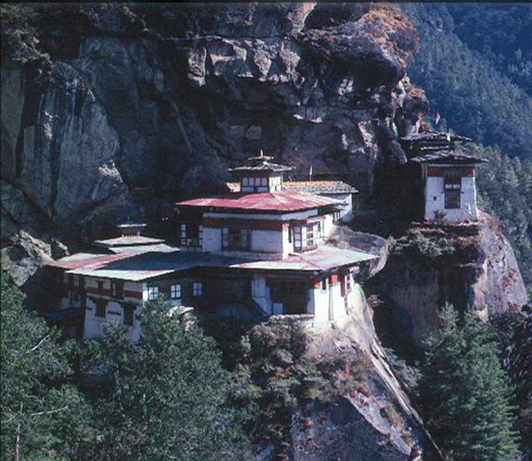
BHUTAN
BHUTAN: GANGKHAR PUENSUUM TREK
TREK DATES: 16 October - 06 November 2011 (ElderFolk 55+ years old)
REGISTRATION DEADLINE: 15 March 2011
TREK FEE: $7650.00 for 6-9 Members or $7025.00 for 10-12 Members
TREK FEE (EXCLUDING AIRFARE): $6525.00 for 6-9 Members or $5840.00 for 10-12 Members
ACTIVITY LEVEL: Trekking, Camping, Hotels
DEPARTURE CITY: Portland, Oregon (airfares available from traveler’s cities)
OVERVIEW:
When you read “ElderFolk” in the description, the Treks are designed for folks 55 years and older. The approximate trek time and altitude gain/loss for our campsites is listed each day (xx hours/xx feet).
As one flies toward Bhutan, great jagged shapes looking like clouds appear outside the airplane. When the plane descends, you realize that these fantastic shapes are the highest mountains anyone has ever seen, the Himalayas. Isolated villages dot the hillsides, ancient footpaths connect the settlements and temples are perched on high cliffs. The houses have wooden shingle roofs held in place by chunks of granite and highlighted by brilliant patches of drying red chilies, the staple of almost every Bhutanese dish.
Bhutan, the "Dragon Kingdom," is the only Mahayana Buddhist kingdom in the world. Because of a deep traditional reverence that the Bhutanese have for nature, the kingdom is one of the leading countries in environmental preservation. It is understood that if the number of tourists exceeds the Kingdom’s capacity and begins to drain resources and harm the environment, the government can restrict the annual number of people allowed to enter Bhutan.
Having been shielded from the outside world until the 1960's, Bhutan has retained the charm of a medieval kingdom. Wedged between the two giant neighbors of India and China, Bhutan’s terrain ranges from the tropical southern foothills near sea level to mountain heights of over 24,000'.
Bhutan’s sustainable development strategy is termed “The Middle Path:” “The capacity and political will to effectively address today’s development and environmental problems and tomorrow’s challenges without compromising Bhutan’s unique cultural integrity and historical heritage or the quality of life of future generations of Bhutanese citizens.”
SCHEDULE:
16 OCTOBER [Saturday] DEPART HOMETOWN
17 OCTOBER [Sunday] ARRIVE BANGKOK: Overnight near the airport.
18 OCTOBER [Monday] BANGOK TO PARO: Depart early on Druk Air for Paro (7701’). If the weather is clear could see Everest, Lhotse, Makalu, the huge massive of Kanchenjunga (four of the world’s five highest peaks) and as we near Bhutan, Chomolhari, the Kingdom’s matron peak. After clearing immigration we will drive across the wide, flat-bottomed Paro Valley to our hotel. We check into our hotel and enjoy a nice lunch. Our afternoon will include a visit the Rinpung (Paro) Dzong and the Ta Dzong (National Museum) which contains works of art and handcrafted objects of daily life, stuffed animals, costumes and armor. Bhutan’s dzongs originally served three purposes: as a fortress, an administrative center of local government, and a residence and focus for the monks’ religious activity.
A short walk takes us to the base of the dzong and across a traditional, cantilevered, covered bridge. We then pass Ugyen Pelri, a small jewel-like palace that belongs to the Royal Family of Bhutan. Designed after the celestial paradise of Padmasambhava, the building was completed in the late 1800s. No alterations have been made to the structure or the beautiful carvings and paintings within the palace. A short distance farther is one of the innumerable archery grounds. Archery is the national sport of Bhutan, and most men grow up learning it. Overnight at the Namsay Choling Resort (BLD)
19 OCTOBER [Tuesday] PARO/THIMPHU: Thimphu was a wooded farming valley until 1961, when it became Bhutan's official national capital. Thimphu is one of the fastest developing towns in Bhutan but still retains some of its quaint charms. It is the only capital in the world that relies on the hand signals of police to move the traffic along. The massive Tashicho Dzong, about 700 years old, was carefully revamped in the 1960s by the late King Jigme Dorji Wangchuk to house the royal and main government offices. It is also the summer residence of the Je Khempo,Bhutan’s chief abbot. King Jigme Dorji Wangchuk was the main architect of modern Bhutan. He died in 1972 and was succeeded by his son, Jigme Singye Wangchuk, who was age 17 at the time. He abdicated the throne in 2006, as Bhutan changed to a constitutional monarchy, and his son, Jigme Khesar Namgyel Wangchuck (then 28), was crowned king and became the head of state in November 2008.
On the early morning (5 hours) drive from Haa to Thimphu (7837’), observe Simthokha Dzong, the oldest fortress of its kind. Located where the roads from Thimphu- Paro-Phuentsholing-Punakha cross, it controls all the approaches to and from Thimpu. Built by Shabdrung Ngawang Namgyel in 1627, it was turned into a religious university in 1961 by the Third King, Jigme Dorje Wangchuck and has just completed a renovation. After lunch, we will enjoy visiting the zoo for Takin and the Arts and Crafts School, where children are trained in traditional Bhutanese painting, sculpture, and woodcarving, and the Folk Heritage Museum as well as some friends. Overnight at TBA Hotel (BLD)
20 OCTOBER [Wednesday] THIMPHU/TRONGSA: Morning departure up onto the western slopes of the Dochu La (3,050 meters), the first of a series of passes. During the 3 hour drive, we enter the pristine forests of hemlock, fir, oak and blossoming magnolias and rhododendrons and we may see a wealth of birds in species-rich feeding flocks. Our drive takes us over the Pele La Pass and into central Bhutan. A picnic lunch along the way gives us a break from driving and an opportunity to observe the local area. Before arriving in Trongsa, we will see the Trongsa Dzong across the valley. Trongsa Dzong is the largest Dzong in Bhutan and served as the gateway between the west and the central Bhutan. Overnight at TBA Guest House. (BLD)
21 OCTOBER [Thursday] TRONGSA/JAKAR: After breakfast we will visit both the Trongsa Dzong and the newly renovated Ta Dzong, the old watchtower above the main Dzong.
After lunch we drive over bamboo-thronged Yuthong La into the first of the four Bumthang valleys Chumey, Choekjor, Tang and Ura - with altitudes varying from 8,500 feet to 12, 125 feet. Chumey and Choekjor are agricultural valleys and Tang and Ura are given over more to yak and sheep breeding. The scenery changes to broad grassy valleys and rolling hillsides covered in spruce and fir and the avifauna alters equally abruptly. Chumey is also noted for weaving yatras, rolls of patterned twill-weave woolen cloth which can be used as bed covers, cushions or even garments. Total driving time is about 3 hours. We will have a weaving demonstration in the afternoon at our lodge by our hostess, Rinzin Wangmo. Overnight at the Leki Lodge. (BLD)
22 OCTOBER [Friday] JAKAR/DHUUR/CHOCHOKMEY: (6 hours/1575’ gain) From our guesthouse we drive up the valley, past the Kurjey temple complex, and along the dirt track that follows the Dhuur Chu until we reach a confluence with some bamboo huts and a suspension bridge that marks the base of Dhuur village (9,183’). This is where we begin trekking across the suspension bridge and follow the track that climbs swiftly to the village. Dhuur comprises about 30 quite substantial-looking houses that reach its full occupancy during the winter months, when the yak-herding families return to seek shelter from the higher elevations. Roughly half the villagers are permanent residents who farm the surrounding lands. Overnight at campsite (BLD)
The trail meanders through Dhuur and dips through bamboo thickets along the course of the Dhuur Chu. We continue along the river until we meet the Gorsuum stream. After crossing the stream over a small wooden bridge, the trail makes a steep climb to a pleasant meadow known as Gorsuum, where we will stop for lunch. The trail continues through thickets of bamboo, rising and dipping but never straying very far from the Dhuur Chu. As we gain altitude the blue pines gradually give way to bigger and denser fir and spruce. These substantial trees provide more shade and space for the larger bamboo that seem to grow everywhere. Our camp for tonight is Chochokmey (10,758’), a small clearing in the woods beside a stream. This area is used in the summer by cattle herders from Bumthang. Overnight at campsite (BLD)
23 OCTOBER [Saturday] CHOCHOKMEY/LOONGSOOM: (4 hours/1300’ gain) Today is a short day for acclimatization—we can’t go too high too fast! We start the day by descending on a rocky trail to the river. The trail continues to roller coaster up and down, gradually gaining in altitude. Along the way we’ll pass through a forest of cypress, pine, rhododendron, and birch. We cross the river several times on wooden bridges and arrive at our second night’s camp at Loongsoom, a small meadow used by yak herders that’s surrounded by juniper trees. Overnight at campsite (BLD)
24 OCTOBER [Sunday] LOONGSOOM/THASHISA: (4 hours/1500’ gain)The trail descends to the banks of the river and follows it, crossing over to one side and then the other over wooden bridges. Close by the river we reach Koobrang, another clearing used by migrating yak herders. The river’s pace has become much swifter, flowing down with an incessant sound that gets louder as the size of the rapids increase. The trail, along what now is fast becoming a foamy-white, swiftly descending torrent, correspondingly increases its pace of ascent. The forest also is changing: the thick bamboo undergrowth gives way to rhododendrons, and fir trees are replaced with spruce and juniper with a wonderful, almost rain-forest feel. Just below tree line we cross over a wooden bridge that immediately takes us to a fork in the trail. The trail to the left heads to a famed hot spring, but we take the trail to the right, continuing along the stream. Suddenly we’re at treeline, with thick rhododendron bushes growing along the towering rocky cliffs above the stream is flowing gently and silently along a small alpine meadow. A short walk in this pleasant solitude takes us to our camp for tonight at Thashisa (13,570’). Overnight at campsite (BLD)
25 OCTOBER [Monday] THASHISA/THOLEYTHANG: (6 hours/1735’ gain, 958’ loss) The trail continues through a magnificent small valley protected by rocky cliffs, heading steadily up to the valley’s head and the settlement of two herder huts called Lazoor. This is the beginning of the vigorous climb to Tholey La. With just a small respite at the source of a summer spring, the climb to the top is unrelenting in its demand to gain height. Fortunately, it’s not too long before we reach the prayer flags atop Tholey La (15,570’) and are rewarded with a swooping view of the classic valley below and the sharp ridges and hidden valleys on either side (to the left are some snow and glaciers we’ll soon see from the other side, as we approach Gangkhar Puensuum). We hike down from the pass, picking our way along the rocky trail past Teyja, a yak camp at the head of a small alpine lake. Keeping to the left of the lake, we skirt its banks and cross over a stream to Tsojab, another yak camp that is summer home to three families. We follow the stream downhill until we reach our camp at Tholeythang (14,620’) just above the tree line. Overnight at campsite (BLD)
26 OCTOBER [Tuesday] THOLEYTHANG/TSAWUU: (6 hours/2023’ loss) After what should be a grand sunrise on the peaks above, we breakfast and begin a descent that takes us down into beautiful forests of tall evergreens. We are now making our final run into the valley that has its beginning at the base of Gangkhar Puensuum. The trail from last night’s camp diverges from the stream and cuts across a ridge heading east, past Kesar, a superbly lonely yak camp with four stone huts perched along a steep ridge. Shortly below Kesar (weather permitting) we may get a view, dramatically framed by the tall trees of the great border peaks of the Bhutanese Himalaya: a maze of ice cliffs that culminates in Gangkhar Puensuum.
We hike down past stout junipers through a gate marking grazing boundaries and emerge onto a pleasant meadow with a large view of densely forested ridges cutting into steep, narrow gorges (one of which we’ll hike through on our way back to Jakar). To the northeast we see a tributary source of the Chamkhar Chu that flows in from the Monla Karchung La, a pass on the Tibet-Bhutan border. The valley on the northwest, with the river still hidden from view, is where we are headed. Far below at the confluence of the two rivers are a couple of houses that serve as barracks for the small contingent of Royal Bhutanese Army stationed here. It’s a lonesome outpost, even for Bhutan.
We make a steep descent along a well-shaded trail, past junipers, spruce, fir, rhododendrons and birch, and past Tokchoong. This is a delightful meadow camp used by yaks owned by the Central Monastic Body of Punakha. We cross a wooden bridge to the right bank of the Chamkhar Chu and onto the meadow known as Tsampa Goma. To make tomorrow’s gradual uphill climb an easier day, we will walk another hour past the yak camp of Buumjan and then to Tsawuu (12,237’). We are now at the very gateway to the great peaks, near the timberline but amid lush forests and looming, rocky ramparts. Overnight at campsite (BLD)
27 OCTOBER [Wednesday] TSAWUU/BUMARPA: (8 hours/2,284’ gain) Our trail follows the Chamkhar Chu to the northwest. The valley of the Chamkhar Chu, inhabited during the warmer six months of the year by the yak herders of Bumthang, is a classic example of the elegantly spaced migration of yaks and their herders. Not far above the meadows of Tsampa Goma is the valley’s first camp and in regular intervals above it are about eight camps. The last of these camps, Buurtsam (“glacial end”), is at the very terminus of the glacial systems that drain from the massive rampart of the Gangkhar massif. Depending on the season, the eight families that graze their yaks in this valley will use any one of these camps. We notice that the forest here is predominantly spruce; the soaring trees making a distinctive dark green pattern along the steep ridges on both sides. As we follow the trail along the right bank of the river and steadily gain altitude, the impressive spruce forests give way to stout, weather-beaten junipers and rhododendron bushes clinging to rocks and ridges above the tree line. As space opens up, the icy wall of the siblings, Gangkhar and its brothers, appear majestically.
We climb gradually to Base Camp. The river decreases to a glacial stream, the valley floor widens, rocks increase noticeably in size and numbers and the ridges on either side are bare and alpine. Our camp is at Bumarpa (14,557’), a yak camp for four families set in a meadow with huge boulders strewn everywhere. Overnight at campsite (BLD)
28/29 OCTOBER [Thursday/Friday] BUMARPA: We have two days for rest and excursions. There are a number of day-hiking possibilities, but we will want to head up from camp to get closer to the great wall. Following the watercourse up the valley for about an hour will get us to Buurtsam, the last of the yak camps. Buurtsam is set at the rocky base of the moraine carved by the main Gangkhar glacier, which is the melding of a score or more of smaller, avalanche-fed glaciers that tumble down from the long, serrated rampart. The yak herders explain that Buurtsam is a new camp. Not long ago this was the edge of the glacier itself and would be iced all through summer. But now, with the glacial stream in retreat, the herders are gaining higher pasture grounds.
From Buurtsam we can keep hiking along the moraine, closer to the peaks. The terrain is rocky but open and easily navigable, offering many tempting routes in search of ever grander views. To be among the very first Westerners in history to wander in these stunning precincts adds to the drama and delight of this rare natural temple. Overnight at campsite (BLD)
30 OCTOBER [Saturday] BUMARPA/TSAMPA GOMA: (8 hours/1,981’ loss) Our trek is all downhill today as we head back down valley and make camp at Tsampa Goma (12,576’) the wonderful meadow near the confluence. Overnight at campsite (BLD)
31 OCTOBER [Sunday] TSAMPA GOMA/PETSO (8 hours/2,349’ loss) Just above camp a wooden bridge takes us over the tributary river, past the army outpost and along the banks of the Chamkhar Chu. The trail skirts along the banks of the Chamkhar as it rises and dips, constantly losing altitude alongside the swift-flowing current. Spruce forests give way to a wildly varietal mix of firs and birch, rhododendrons and bamboo thickets, which keep getting bigger and taller as we descend. The huge cliffs overhanging the other side of the river, reminiscent of a Chinese landscape painting, make it clear why we’re on this side of the river.
After about six hours of hiking we reach Bong Zam (zam means “bridge”), where a new suspension span replaces the old wooden one. We make a short climb after the bridge and then dip down again to follow the river past tall fir trees. A wooden bridge takes us to the river’s left bank, and we descend past a lovely confluence called Saduksum and farther on till we reach the quiet Petso (10,227’) meadow where the river flows smoothly. Overnight at campsite (BLD)
01 NOVEMBER [Monday] PETSO/NGANG: (6 hours/727’ loss) We continue following the river, encountering a wooden bridge about 1 ½ hours from camp. Bypassing the bridge, we stay on the right bank, rising and falling, but always staying close to the rushing stream. As the forest changes from fir to blue pine we come to the first permanent settlement in quite some time, the army barracks of Khagthang, built in a wonderful large meadow. Looking down from Khagthang we see the village of Nasphey, with temples and meditation houses nestling in the forests above. Down we go, past the village’s cultivated fields to Shabthang, a village with an old temple built in honor of Padmasambhava (also known as Guru Rimpoche, or the Precious Teacher, who brought Buddhism to Bhutan in the 8th Century). Padmasambhava meditated here, as he did throughout the Bumthang region, which is why it is so revered in Bhutan. Coming into Guru Rimpoche country is a sign that we are nearing the end of our journey.
We walk past the local primary school (perhaps with a moment or two of dallying with its enthusiastic youngsters and teachers) and shortly arrive at the suspension bridge of Damphey villages. Over the bridge and past the village, we continue along fields of winter wheat, millet and buckwheat, to the gloriously picturesque village of Ngang (9,500’). Overnight at campsite (BLD)
02 NOVEMBER [Tuesday] NGANG/THOKO ZAM/JAKAR: (4 hours/900’loss) Our trail leads through the village houses and fields of Ngang, past meadows and blue pine forests and bamboo thickets, keeping to the left bank of the Chamkhar Chu. We cross to the right bank over a suspension bridge, pass the village of Tangbi with its wonderful old temple, and finally reach the Thokto Zam (8,600’), a bridge that spans the Dhuur River. A quick climb up from the bridge and we reach the motor road where our bus and driver wait to take us to our guest lodge. Overnight at the Leki Lodge. (BLD)
03 NOVEMBER [Wednesday] JAKAR/PUNAKHA: Most of our day will be spent driving to Punakha. We will stop for lunch enroute and, if time allows, spend some time walking in the afternoon after we arrive at our hotel. Overnight at TBA Guesthousel (BLD)
04 NOVEMBER [Thursday] PUNAKHA/THIMPHU: After our drive over Dochu La, we arrive in Thimphu in time to check into our hotel and enjoy a few hours free time to explore the town. A couple activities are planned before our farewell dinner this evening. Overnight at TBA Hotel (BLD)
05 NOVEMBER [Friday] THIMPHU/PARO/BANGKOK: Early drive to Paro to board our Druk Air flight to Bangkok where Folkways Institute’s services end. We would be pleased to book your Bangkok overnight hotel, if you wish.
06 NOVEMBER [Saturday] BANGKOK/HOME
(The schedule, cost and accommodations are subject to change)
Bhutan - Trashigang Tshechu

FUTURE JOURNEYS UNDER DEVELOPMENT
Watch for new itineraries or contact us regarding future schedules.
BHUTAN: Royal Manas Eco-Tourism Research Project
Manas has been closed to all foreigners, but we are being given special permission to visit. The park is located in the Eastern Himalaya foothills. The park is densely forested. The Manas river is the main river, a major tributary of Brahmaputra river. The Manas River flows through the west of the park, further it splits into two separate rivers, the Beki and Bholkaduba. Manas and five other small rivers flow through the National Park which lies on a wide low-lying alluvial terrace below the foothills of the outer Himalaya.. The combination of Sub-Himalayan Bhabar Terai formation along with riverine succession continuing up to Sub-Himalayan mountain forest making it one of the richest biodiversity areas in the world. The park is 391 km². in area and situated at a height of 61m to 110m above mean sea level.
The park has recorded 55 species of mammals, 380 species of birds, 50 of reptiles, and 3 species of amphibians. Out of these wildlife, 21 mammals are India’s Schedule I mammals and 31 of them are threatened.
The fauna of the park includes Asian Elephants, Indian Rhinoceros, Gaurs, Asian Water Buffaloes, Barasingha, Tigers, Leopards, Clouded Leopards, Asian golden cat, Capped Langurs, Golden Langurs, Assamese Macaques, Slow Loris, Hoolock Gibbons, Smooth-coated Otters, Sloth Bears, Barking Deer, Hog Deer, Sambar Deer and Chital.
The park is well knownfor its rare and endangered wildlife which is not found anywhere else in the world like the Assam Roofed Turtle, Hispid Hare, Golden Langur and Pygmy Hog.
Manas houses about 380 species of birds. Manas have the largest population of endangered Bengal Florican. The major other birds includes Giant Hornbills, Jungle Fowls, Bulbuls, Brahminy Ducks, Kalij Pheasants, Egrets, Pelicans, Fishing Eagles, Serpent Eagles, Falcons, Scarlet Minivets, Bee-Eaters, Magpie Robins, Pied Hornbills, Grey Hornbills, Mergansers, Harriers, Ospreys and Herons.
SERVICE PROJECTS
Folkways Institute is a 501-c-3 nonprofit educational organization. We support the following projects and your contributions to the Institute are tax deductible as the law allows under the IRS rules (note: 100% of your contribution goes to the project and no administrative fees are deducted).
NEPAL: LED Light Project: The villages that have received these lights are a 5 day walk from the trailhead. It is our understanding that that someone will be going to the remote area of Nepal with a camera to take pictures this fall.
BHUTAN: LED Light Project: Pictures of the villages and homes in this remote area of Bhutan’s Haa Valley will be taken this December and posted in our winter newsletter.
BHUTAN: Haa Valley Community Rice Huller: Hulling rice is a major, time consuming activity in every rice growing Bhutan village. A rice huller would relieve a large, time consuming burden on the farming women. We have sent funds to purchase one grinding mill at a cost of $145.00 USD. We would be pleased with any tax-deductible contributions for this project.
BHUTAN: Table Oil Expeller for Mustard Oil: The Oil Expeller provides cooking oil for the village families as well as creates a cash crop product that the village families can sell. The Oil Expeller would be a tremendous boost for assisting the village families. We have sent funds to purchase one Oil Expeller at a cost of $395.00. If you would like to send a tax-deductible contribution, it would be appreciated.
PERU: Kids at the Crossroads: We ask you to help us support a new project founded by one of our former workers, GeGe Coleman. She has started Kids at the Crossroads in Ayacucho, Peru. If you would like to know more about GeGe’s work, please send us a note.
Parks of Patagonia - Mt. Fitzroy


No comments:
Post a Comment